
The State of Jammu and Kashmir falls in the great north-western complex of the Himalayan ranges with marked relief variation, snow-capped summits, antecedent drainage, complex geological structure and rich temperate flora and fauna. Geologists believe that approximately ten million years have passed since the Kashmir valley which was once a lake called Satisar, the lake of goddess Sati, came into its present form. For hundreds of millions of years, the Kashmir valley was submerged beneath the Tethys Sea and the high sedimentary rock hills visible in the valley today were once underwater. Geologists have come to believe that Kashmir valley was earlier affected by earthquakes. Once, a devastating earthquake broke open the mountain wall at Baramulla and the water of the Satisar Lake flowed out, leaving behind lacustrine mud on the margins of the mountains, known as areas. Thus, came into existence the oval but irregular valley of Kashmir. The care was, in fact, the remnants of this lake confirming this view.
The areas are mainly found to the west of the river Jhelum where these tablelands attain a height of about 380 meters above the level of the valley. These areas protrude towards the east and look like tongue-shaped spurs with deep ravines. Ancient legends and popular traditions claim that Samdimat Nagar, the capital of the kingdom of Sundra Sena, was submerged as a result of an earthquake and the water that filled the area formed the Wular Lake, the largest freshwater lake in India. The oldest igneous rocks are still found at Shankaracharya Hills. When the whole valley of Kashmir was under water, this hillock was the first piece of dry land lying in the form of an igneous island. The significance of its name lies in the fact that historians claim the Kashmir valley was initially known as Kashyapmar or the abode of Kashyap Rishi. It is said that the Rishi once went on a pilgrimage to Kashmir. When he reached Naukabandan near Kaunsarnag via Rajouri, he killed Bahudev, the Giant of Satisar at the request of the people and allowed the water of the lake to flow out near Baramulla. The land, therefore, came to be known as Kashyampar which later evolved into Kashmar and subsequently to Kashmir. However, some historians believe that when the people of the Kash caste settled here permanently, the valley came to be known as Kashmir. Kashmir is known by many other names also.
The Greeks called it Kaspeiria while the Chinese named it Shie-in or Kia-Shi-Lo. The Tibetans called it Kanapal and the Dards referred to it as Kashart. The State of Jammu and Kashmir which had earlier been under Hindu rulers and Muslim sultans became part of the Mughal Empire under Akbar in 1586. After a period of Afghan rule from 1756, it was annexed to the Sikh Kingdom of Punjab in 1819. In 1820, Maharaja Ranjit Singh took over the territory of Jammu to Gulab Singh. In 1846, Kashmir was also made over to Gulab Singh under the Treaty of Amritsar. Ladakh was annexed by Maharaja Gulab Singh in 1830. Thus, this northernmost state was founded by Maharaja Gulab Singh in 1846 and was the largest princely state in India before the country’s partition in August 1947. At that time, the total area of the state was 2,22,236 sq. km. Pakistan again made an unlawful claim to possession over Chhamb, Deva, Chakla and Manawar, gaining an area of 3,999 sq. km. Thus, the total area left on the Indian side is about 12850 sq. km. There are many low-lying valleys in the state such as the Tawi valley, Chenab valley, Poonch valley, Sind valley and Liddar valley. However, the central valley is the valley of Kashmir which is approximately 100 kilometres long and 15520.3 sq. km wide in area. Through this, the valley flows the River Jhelum along with its tributaries. The height of the valley above sea level is about 1700 metres. On the map of India, the State of Jammu and Kashmir looks like a crown. The State is 640 km in length from north to south and 480 km from east to west.
Afghanistan and Pakistan now have come close to the boundaries of the state of Jammu and Kashmir. The proximity to the boundaries of foreign countries has made the state’s position most important from a military point of view. The standard time is 5:30 hours ahead of Greenwich Mean Time as in the rest of India and has a difference of half an hour with the local time. In latitude, the state of Jammu and Kashmir corresponds with South Carolina. Geographical Importance of Kashmir is renowned for its beauty and natural scenery worldwide. Its high snow-clad mountains, scenic spots, beautiful valleys, rivers with ice-cold water, attractive lakes and springs, evergreen fields, dense forests and beautiful health resorts enhance its grandeur and are a source of great attraction for tourists. It is also widely known for its different kinds of agricultural products, fruit, vegetables, saffron, herbs, minerals, precious stones, handicrafts like woollen carpets, shawls and the finest kind of embroidery on clothes. During the summer, one can enjoy the beauty of nature as well as trout fishing, big and small game hunting etc. During winter, activities such as climbing mountain peaks and sports like skating and skiing on snow slopes are commonly enjoyed. In addition to the above, Pilgrimages to famous religious shrines of Hindus and Muslims make Kashmir a great tourist attraction.
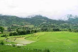
The state of Jammu and Kashmir falls in the great north-western complex of the Himalayan ranges with marked relief variation, snow-capped summits, antecedent drainage, complex geological structure and rich temperate flora and fauna. Kashmir, also known as the Jhelum valley, is situated between the Pir Panjal range and the Zanskar range, covering an area of 15220 sq km. It is bounded on all sides by mountains. The River Jhelum which flows out from the spring at Verinag in Anantnag district, passes through this valley at a very slow speed and ultimately flows out through a narrow gorge at Baramulla. The districts of Srinagar, Anantnag, Baramulla, Kupwara and Pulwama lie in this valley. The average height of the valley is 1850 metres above sea level but the surrounding mountains which are always snow-clad, rise from three to four thousand metres above sea level. The surface of the valley is plain and abounds with springs, lakes and health resorts.
